


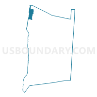
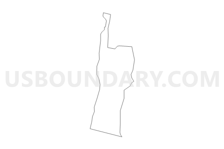
Voting District 170005, Dutchess County, New York
About
Outline

Summary
| Unique Area Identifier | 626401 |
| Name | Voting District 170005 |
| County | Dutchess County |
| State | New York |
| Area (square miles) | 9.51 |
| Land Area (square miles) | 5.91 |
| Water Area (square miles) | 3.61 |
| % of Land Area | 62.10 |
| % of Water Area | 37.90 |
| Latitude of the Internal Point | 42.02150860 |
| Longtitude of the Internal Point | -73.92631510 |
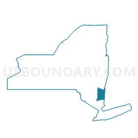
Maps

Graphs
Select a template below for downloading or customizing gragh for Voting District 170005, Dutchess County, New York


Neighbors
Neighoring Voting District (by Name) Neighboring Voting District on the Map
- Voting District 060001, Columbia County, NY
- Voting District 160003, Ulster County, NY
- Voting District 160008, Ulster County, NY
- Voting District 170001, Dutchess County, NY
- Voting District 170002, Dutchess County, NY
- Voting District 170003, Dutchess County, NY
- Voting District 170004, Dutchess County, NY
- Voting District 170007, Dutchess County, NY
- Voting District 180002, Dutchess County, NY
- Voting District 180006, Dutchess County, NY
- Voting District 190012, Ulster County, NY
Top 10 Neighboring County Subdivision (by Population) Neighboring County Subdivision on the Map
- Saugerties town, Ulster County, NY (19,482)
- Ulster town, Ulster County, NY (12,327)
- Red Hook town, Dutchess County, NY (11,319)
- Rhinebeck town, Dutchess County, NY (7,548)
- Clermont town, Columbia County, NY (1,965)
Top 10 Neighboring Place (by Population) Neighboring Place on the Map
- Saugerties village, NY (3,971)
- Saugerties South CDP, NY (2,218)
- Glasco CDP, NY (2,099)
- Tivoli village, NY (1,118)
Top 10 Neighboring Unified School District (by Population) Neighboring Unified School District on the Map
- Kingston City School District, NY (51,596)
- Saugerties Central School District, NY (20,744)
- Red Hook Central School District, NY (14,033)
- Rhinebeck Central School District, NY (9,711)
- Germantown Central School District, NY (4,660)
Top 10 Neighboring State Legislative District Lower Chamber (by Population) Neighboring State Legislative District Lower Chamber on the Map
- Assembly District 103, NY (134,686)
- Assembly District 127, NY (129,764)
- Assembly District 101, NY (128,454)
Top 10 Neighboring State Legislative District Upper Chamber (by Population) Neighboring State Legislative District Upper Chamber on the Map
Top 10 Neighboring 111th Congressional District (by Population) Neighboring 111th Congressional District on the Map
Top 10 Neighboring Census Tract (by Population) Neighboring Census Tract on the Map
- Census Tract 9513, Ulster County, NY (4,337)
- Census Tract 9503, Ulster County, NY (4,317)
- Census Tract 9502, Ulster County, NY (3,968)
- Census Tract 1500.04, Dutchess County, NY (3,613)
- Census Tract 1500.03, Dutchess County, NY (3,027)
- Census Tract 1600.03, Dutchess County, NY (2,361)
- Census Tract 19, Columbia County, NY (1,965)
- Census Tract 9549, Ulster County, NY (1,585)
Top 10 Neighboring 5-Digit ZIP Code Tabulation Area (by Population) Neighboring 5-Digit ZIP Code Tabulation Area on the Map
- 12571, NY (9,918)
- 12572, NY (9,123)
- 12526, NY (3,686)
- 12583, NY (2,451)
- 12504, NY (1,395)
- 12507, NY (167)